


Sheffield’s first “low traffic neighbourhood” was created in the Kelham Island area on Saturday to encourage and support walking and cycling in the area.
UPDATED: Thursday 9 July. New Statement from Sheffield City Council following resident and business feedback added below.
Low Traffic Neighbourhood
A low traffic neighbourhood is an area where traffic is restricted or discouraged to promote healthier and less polluting forms of travel.
Sheffield City Council have made these temporary changes in Kelham Island as part of their response to the Covid-19 pandemic. Consequently, pedestrians traversing the area have more space to social distance and active travel is encouraged.
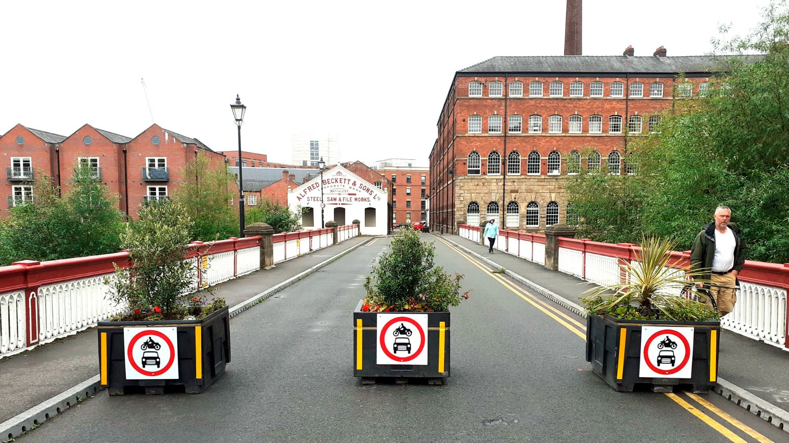
Kelham Island roads closed
Barriers have been placed in sections of Alma Street — outside the Fat Cat pub — and on Ball Street bridge. Additional road blocks have been placed at the entrances to Ebenezer Street, Shepherd Street and at the end of the throughway from Penistone Road to Cornish Street.

Traffic flows one-way from the throughway past Globe Works to Green Lane and Cornish Street.
“Creating a low–traffic neighbourhood in Kelham Island and Neepsend we will open up a space for residents to safely walk and cycle without traffic.”Councillor Bob Johnson, Cabinet Member for Transport and Sustainability
Alternative traffic routes suggested include Dun Street, Dun Fields, Doncaster Street and via the West Bar Roundabout.
Hey @PeteZanzottera @DameSarahStorey looks like that planter drought is over ? pic.twitter.com/EKDvEiLpkW— robert johnson (@Bob_of_Hills) July 4, 2020
Of course access will remain available for residents, deliveries and disabled visitors. However, drivers should check for any parking restrictions in place around the area before stopping.

Cycle lane created on Shalesmoor
Another addition to the Shalesmoor area this weekend has been the creation of a temporary cycle lane.
The new cycle-friendly path runs from the Shalesmoor roundabout to Corporation Street, near the junction with Alma Street. The new cycle lane takes up part of existing road traffic lanes. Subsequently, barriers have been placed to separate cyclists from motor traffic.
More people are walking and cycling in #Sheffield so we’ve put a temporary cycle lane on the A61, between Shalesmoor roundabout and the Corporation St junction.
More information & maps at https://t.co/FpZ4Ek1vd3 pic.twitter.com/bB9O4af87E— SheffieldCityCouncil (@SheffCouncil) July 4, 2020
“Providing the right infrastructure is absolutely essential to changing our habits and becoming more sustainable in how we travel. This new cycle link will give cyclists their own dedicated route for getting across town and I also hope that it will encourage people who don’t usually cycle to give it a go.”Councillor Bob Johnson, Cabinet Member for Transport and Sustainability
More low traffic neighbourhoods to come
Whilst the Kelham Island scheme is a temporary one, many are hoping for permanent changes. The current pandemic is seen to be a catalyst for trialling and implementing such plans.
It has been hinted that more low traffic neighbourhoods are to follow. Sheffield City Council are certainly exploring more “active travel measures” across the city.
“The Council has received a lot of requests to pedestrianise more areas of our city. I’m looking forward to seeing the results of this scheme and hope it can be replicated in more areas of Sheffield in the future.”Councillor Bob Johnson, Cabinet Member for Transport and Sustainability
One of the more popular calls for pedestrianisation has been for Division Street in Sheffield City Centre. A trial road closure was held in October last year, and of course part of Division Street has been closed to traffic during the pandemic to allow for social distancing.
Close the road, open the street pic.twitter.com/asAY5XSRXE— CycleSheffield (@CycleSheffield) July 5, 2020
Update: Sheffield City Council statement, Thursday 9 July
Sheffield City Council today issued a further statement from Councillor Bob Johnson following resident and business feedback:
“The Council is committed to enhancing walking and cycling as a means of reducing congestion, improving air quality, increasing physical activity and creating attractive places. Covid-19 presented an opportunity to trial pedestrianisation and dedicated cycle lanes in a number of areas around the city and, whilst early days, a number of these such a Pinstone Street are already proving popular and successful.
“The Covid-19 pandemic and Government funding for temporary transport measures enabled us to trial a temporary scheme on Shalesmoor, which went live this week. We understand the ring road is critically important for vehicles, in to and around the city and dedicated cycle lanes in this area is something that has long been called for by active travel groups.
“We have listened to feedback, and we are carefully reviewing the impact of the scheme, making a number of changes in response to concerns from some residents and businesses. It is important that we continue to work with relevant groups and those affected by the changes so that we can make informed decisions about future active travel measures. We will continue to monitor the impact of these temporary measures and if, once the full impact is known, they are not considered to be delivering the scale of benefits that justify the disruption to the ring road, then a decision will be taken on the appropriate time to withdraw this temporary scheme.”Councillor Bob Johnson, Cabinet Member for Transport and Sustainability
He turned 2 last week, rode on Sheffield ring road this week.
I asked her, 3: (“Do you like riding on the special new bike-only road?”) “Yeah! … I want to go further.”
?
Thanks @Bob_of_Hills, @SheffCouncil, @CycleSheffield etc… pic.twitter.com/hv4atcKglP— Sam Wakeling (@samwake) July 9, 2020
Other changes in Sheffield
Sheffield City Council have implemented many temporary changes across the city to help accommodate social distancing measures, including:
- A number of social distancing measures have been implemented across the city centre, including; closing part of Division Street to traffic, closing parts of Pinstone Street to traffic, widening footpaths on high-footfall routes, etc
- Footpath widening in various areas across Sheffield including; Chapeltown, Crookes, Darnall, Frecheville, Gleadless Townend, Hillsborough, Manor Top and Stocksbridge
- Cycle lanes on Attercliffe Road between Princess Street and Stevenson Road to create a continued route for the Five Weirs Walk
The council also state they are considering bringing forward planned road closures, more temporary active travel lanes and more pedestrian safety zones.
We’ve temporarily closed Ball Street bridge and Alma St in Kelham Island to make it easier and safer to walk and cycle there.
More info & maps ? https://t.co/FpZ4Ek1vd3 pic.twitter.com/M4xhUJBYxG— SheffieldCityCouncil (@SheffCouncil) July 4, 2020
Discover the very best of the Steel City with The Sheffield Guide Newsletter!
Sign up now to receive occasional updates from The Sheffield Guide. All the latest Steel City information direct to your inbox!
Free to subscribe. No-spam guarantee. Unsubscribe at any time.


![[SHF] Launches new Sheffield fashion collection](https://i0.wp.com/www.sheffieldguide.blog/wp-content/uploads/2021/01/SHF-Fashion-Collection-1.jpg?resize=100%2C100&ssl=1)


